Topographical Surveying & LiDAR Mapping

Topographical Surveying & LiDAR Mapping UAE
High Accuracy Terrain Intelligence Through Advanced Drone Surveying Services UAE
In large scale infrastructure, engineering, and land development projects, terrain accuracy defines project success.

Topographical errors lead to drainage failures, alignment issues, rework, and financial loss. In the UAE’s rapidly developing landscape from coastal developments to desert infrastructure corridors precise elevation modeling is critical.
Modern surveyors and engineering consultants are integrating Drone Surveying Services UAE and LiDAR enabled Aerial Drone Survey UAE solutions to achieve measurable, high-density terrain intelligence.
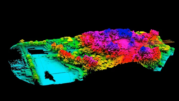
Case Perspective: Corridor Mapping for Infrastructure Planning
During a large linear corridor study in the Northern Emirates, traditional survey methods struggled to capture complex terrain variations across long distances.
By deploying advanced UAV mapping combined with LiDAR scanning:
• High density point clouds were generated
• Vegetation penetration enabled accurate ground modeling
• Digital Terrain Models (DTM) were extracted with high precision
• Geospatial Mapping UAE outputs supported alignment validation
• GIS Mapping Services UAE datasets integrated into engineering design workflows
The project team gained faster data turnaround and significantly improved terrain clarity.
This demonstrates how UAE Drone Mapping Services UAE support high-level infrastructure planning.
Strategic Consultation for Topographical & LiDAR Projects
If your project requires:
-
Advanced Drone Surveying Services UAE
-
LiDAR-enabled Aerial Drone Survey UAE
-
Geospatial Mapping UAE
-
High precision drone survey for construction UAE
-
3D Mapping & Modelling UAE
We deliver engineering-grade terrain intelligence built for complex development environments.